|
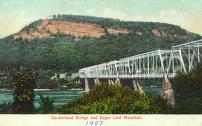
Sunderland Bridge and Sugar Loaf Mountain
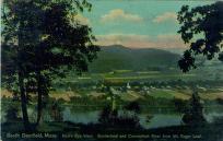
Birds-Eye View, Sunderland and Connecticut River from Mt. Sugarloaf
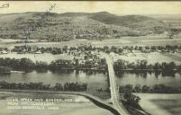
Connecticut River and Sunderland Bridge from Mt.Sugarloaf
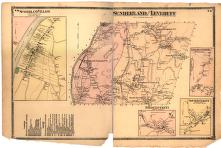
"Sunderland and Leverett"
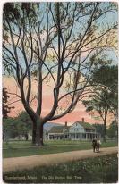
Sunderland, Mass. The Old Button Ball Tree
|
Summary and Objective
Students will look closely at the similarities and differences in the landscapes of Sunderland and Deerfield, MA. To complete this activity, students will use the American Centuries Website section called "In the Classroom," "Everyday Life in a New England Town," Lesson 1: "The Topography and Geology of Deerfield."
Students will understand that geology and topography was used to choose locations for these neighboring towns.
Teaching Plan
Step 1.
Students will read about the glacial period and the Laurentide Ice Sheet that covered most of New England. Students will create a geological timeline using the resources from Professor Richard Little's material: Dinosaurs, Dunes, and Drifting Continents and other web sites related to the glacial period. Students will understand that humans have only been on Earth for a very short time.
Step 2.
Students will locate land formations within the towns of Sunderland and Deerfield on the topographic map. Students will then trace on their maps the route from Mt. Sugarloaf to Mt. Toby via the dunes and delta up current day Bill Hill Road. Students will understand that the land formations in this river valley greatly influenced the selection of these and other town sites.
Step 3.
Students will look at the layout of the both of the old town "streets" to look for similarities and differences. Students will understand that both towns were layed out along a main street on a river terrace where each settler was given a house lot, a wood lot, and tillable land.
Step 4.
Evidence of learning will be the completed timeline, the traced route from Sugarloaf to Toby, the location of landmarks (such as student's house, the school, etc.) on the topographic map, and the labeling of house lots, wood lots, and tillable land on the old town street maps.
Step 5.
Using the images selected with this lesson, try to pinpoint on the map the location the painter or photographer at the time the image was created.
|


