|

1704 Captives March to Canada
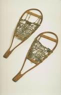
John Sheldon (1658-1733) Snowshoes
|
Summary and Objective
Students will become familiar with New England geography by locating the route of the Deerfield captives of 1704 who were taken by the French and Indians to Canada. Students will understand that travel from Deerfield to Canada in late winter of 1704 was done on foot with the help of snowshoes, which were new to the English at this time. Students will improve their map skills by transferring the route taken by the captives to a modern day map, noting terrain, rivers and distance traveled by the captives. They will use snowshoe symbols to mark their own outline maps.
Teaching Plan
Step 1.
A background activity to add more context to the lesson is to read chapters 8 & 10 in "Boy Captive of Old Deerfield" by Mary P. Wells Smith (Deerfield, MA:Pocomtuck Valley Memorial Association, 2000). A relevant paragraph from page 81 to read aloud follows: "Leaving the great logs of their camp-fires still smouldering and the wigwam poles standing, again the dreary march was taken up for the north, every step bearing the unhappy captives farther and farther from home and the chance of rescue, nearer and nearer to they knew not what terrible fate. Mr. Williams, like the other men, was compelled to bear a heavy pack on his back. Thus laden, and unaccustomed to snow-shoes, difficult, indeed, was it to travel."
Step 2.
On computers, have students read about John Sheldon's snowshoes from the image on the American Centuries web site. (Or print out this information and picture for students.)
Step 3.
Print out a copy of the Map and label, "1704 Captives March to Canada" for each student to study and read.
Step 4.
Go to New England Map/ Quiz Printout at www.enchantedlearning.com/usa/statesbw/newengland.shtml, which is hotlinked below. Print out and enlarge the map of New England. (Or use a New England outline map from your classroom collection.)
Step 5.
On the outline map, students will find and draw the captives' route, using little snowshoe symbols to represent the route. Also on the outline map, students should label the Winooski and Connecticut Rivers, Old Deerfield, Boston and any other points of interest.
Step 6.
Finally on the outline map, students should write a map title, a compass rose, scale, and legend.
Step 7.
Upon completing the map, discussion questions might include: Why might the captors have chosen the route that they did? Where might the traveling have been hard? What geographical features might have made travel difficult at this part of the journey?
Step 8.
As a follow-up activity, students might enjoy making snowshoe models. After careful study of John Sheldon's snowshoes, using the "look closer feature", have students use willow branches and yarn to make minature models of the snowshoe. (A snowshoe of 4 inches by 2 inches works well.)
|


