icon for Home page
icon for Kid's Home page
icon for Digital Collection
icon for Activities
icon for Turns Exhibit
icon for In the Classroom
icon for Chronologies
icon for My Collection

Online Collection

document
(c) Pocumtuck Valley Memorial Association, Deerfield MA. All rights reserved.
Contact us for information about using this image.


label levels:

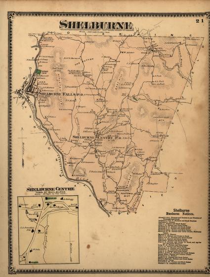
Frederick W. Beers (1839-1933), a cartographer, was hired by towns in Massachusetts to create maps of the various towns. Incorporated in 1768 and named for the English Lord Shelbun, the town of Shelburne, Massachusetts, on the Deerfield River was settled largely by the descendants of Deerfield settlers who needed land for farming and was originally referred to as Deerfield Northwest or Deerfield Reserve. The land was cultivated largely for orchards and for raising sheep. The Beers map locates the villages and rivers within the town, and names many of the major retail and manufacturing establishments present in the second half of the 19th century.


top of page

"Shelburne"

publisher   F. W. Beers and Company
cartographer   Frederick W. Beers (1839-1933)
date   1871
location   New York
height   15.5"
width   12.0"
process/materials   lithograph, paper, ink, watercolor
item type   Maps/Cadastral
accession #   #L02.011


Look Closer icon My Collection icon Detailed info icon


ecard icon Send an e-Postcard of this object


See Also...

Shelburne Falls, Mass Birds-Eye View

Lamson, Goodnow and Company, Birds-Eye View

"Shelburne Falls, Mass."

Austin Towers' receipt from the Shelburne Falls Marble Co.


button for Side by Side Viewingbutton for Glossarybutton for Printing Helpbutton for How to Read Old Documents


Home | Online Collection | Things To Do | Turns Exhibit | Classroom | Chronologies | My Collection
About This Site | Site Index | Site Search | Feedback