icon for Home page
icon for Kid's Home page
icon for Digital Collection
icon for Activities
icon for Turns Exhibit
icon for In the Classroom
icon for Chronologies
icon for My Collection

Online Collection

document
(c) Pocumtuck Valley Memorial Association, Deerfield MA. All rights reserved.
Contact us for information about using this image.


label levels:

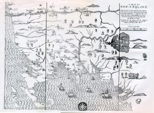
This map, the first printed in England's American colonies, illustrates the geographic extent of King Philip's War (1675-1676). Oriented with west at the top, the Map of New-England shows the pattern of colonial settlement moving from the Atlantic coast inland to the Connecticut River valley. Tribal names ("Nipmuck") and locations ("Mount-hope," Philip's village) indicate the Native presence. Numbers on the map identify villages that had experienced attacks during the conflict.


top of page

"Map of New-England"

publisher   William Hubbard
date   1677
location   Boston, Massachusetts
height   14.0"
width   16.0"
process/materials   printed paper, ink
item type   Maps/Topographical
accession #   #L98.017


Look Closer icon My Collection icon Detailed info icon


ecard icon Send an e-Postcard of this object


See Also...

"Eulogy on King Philip as Pronounced at the Odeon"

Mt. Sugarloaf showing King Philip's Seat

"Philip. King of Mount Hope"


button for Side by Side Viewingbutton for Glossarybutton for Printing Helpbutton for How to Read Old Documents


Home | Online Collection | Things To Do | Turns Exhibit | Classroom | Chronologies | My Collection
About This Site | Site Index | Site Search | Feedback