|
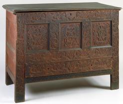
"RA" Carved Chest
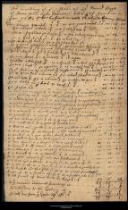
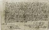
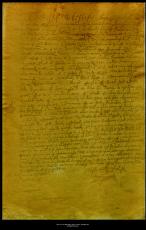
Inventory of David Hoyt
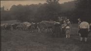
"Leaving for Bloody Brook"
Side chair with leather upholstery
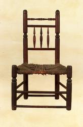
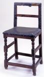
Side Chair
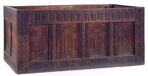
Chest
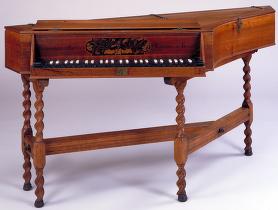
Spinet
Deed of Pacomtuck land granted by Chauk to Dedham residents
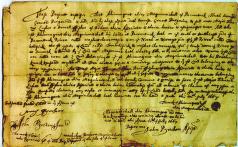
Deed of Pacomtuck land granted by Ahimunquat to Dedham residents
Deed of Pacomtuck land granted by Mashalisk to John Pynchon
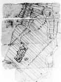
Lot Survey of Deerfield
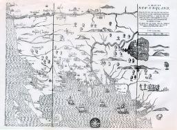
"Map of New-England"
|
Summary and Objective
Students will understand, through the use of maps, deeds and activities, that living on the frontier was not just the "wild west" of Sterling Hayden and Maureen O'Hara, but was experienced in western New England close to two centuries earlier. In fact, the fear, struggle and privations may cause the students to ask the proverbial question, "What were they thinking?!"
Teaching Plan
Step 1.
Pre-activity for steps #2-3: Using an atlas to gain familiarity with a modern New England map, identify the bodies of ocean water (Massachusetts Bay to Long Island Sound) and major rivers (Merrimac, Charles and Connecticut), and the towns along them that are shown on the maps attached to this lesson and the 1704 site "Settlement Patterns in the Connecticut River Valley" and "Colonial Northeast". These will show the settlement patterns and growth inland.
Step 2.
Use "Map of New England" attached to this lesson, and the following link, look at the maps "Settlement Patterns in the Connecticut River Valley" and "Colonial Northeast" http://1704.deerfield.history.museum/maps/northeast.html . Then use the links to the Wikipedia websites to get incorporation dates and connections of settlements progressing from the coasts of Massachusetts Bay and rivers along it, up the Connecticut River. For example, many of the settlers of Enfield, Connecticut (which was part of Massachusetts until the late 17th century) were from Salem and many of Deerfield's were from Dedham.
Use the deeds and the lot survey of Deerfield (including using the "activities" button) attached to this lesson to make these connections with coastal settlers migrating to the frontier. As you collectively look at the locations of Dedham, Salem and even Enfield, elicit from the students ideas of why people would seek to move so far to Deerfield.
A coordinate graph, plotting dates of incorporation vs. the distance from the ocean shoreline, can help illustrate the influence of transportation ease and difficulty in settlement patterns.
Step 3.
"How do you decide on the location for a town on the frontier?" The ensuing discussion should revolve around safety, proximity to usable transportation routes and corridors, and the challenges of shipping what you need to your home, and what you produce to your customers.
Step 4.
Pre-activity for steps #5-7: Make these lists -
1) What objects and materials are built into your house (e.g windows, wood, plaster, wallpaper, cabinets, chimney, foundation)?
2) What do you have in your house that makes your life comfortable (e.g. windows, furniture, light fixtures, heat sources, electronics, appliances, utensils, bedding)? Now, remove those from your list that rely on electricity or carbon based fuels.
Step 5.
What would you pack up and move in a wagon to get to your frontier home? Use the images of chests for personal items that the settlers could bring. Use "The inventory of David Hoyt" to show the possessions at the turn of the 18th century. Use the images from "Leaving for Bloody Brook" to show what limitations settlers faced in carrying essential family possession (e.g. furniture, clothing, cooking, tools for farming, building and repairing) as they migrated to the frontier.
Step 6.
Using the Wells Thorne house images from http://www.memorial hall.mass.edu/activities/architecture/wellsthorne_ell.html and those of the furniture attached to this lesson, explore what was owned, the dates of their building or manufacture, and the Spartan nature of the house's interior. What was used? What luxuries were there? Then contrast these with the image of the spinet attached to this lesson. It was built in 1680 but did not come inland until the early 19th century. Because some parts of the houses and some possessions could be constructed on site, explore tools and how they were used from http://www.memorialhall.mass.edu/activities/tools/ index.html .
Step 7.
Present to the students: What will you need through the school year in class (e.g. books, stationary supplies, warm clothing)? Using the dimensions of the chests attached to this lesson, can you include everything? Now, how about what you need at home (bedding, sports clothing and materials, musical instruments, toys/hobbies/entertainment)? This can illustrate what the settlers were faced with in such a presumably permanent move.
|


