Send an E-Postcard of:
"Sunderland and Leverett"
(c) Pocumtuck Valley Memorial Association, Deerfield MA. All rights reserved.
Contact us for information about using this image.
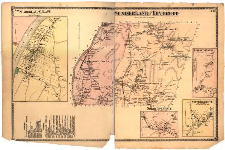
The map of the village of Sunderland, Massachusetts, clearly shows the long-lot patterns of land ownership, a legacy of the original Puritan-era plats. The long farm holdings stretched from the town's single long street either down to the riverside or inland, extending from the houses. The long street design is very similar to that of Deerfield, Longmeadow, and other towns of the Connecticut Valley. Then, as now, Mt. Toby dominated the landscape of Sunderland, its rugged flanks making settlement difficult. Leverett, Massachusetts, in 1871 was a thriving industrial center, with industries taking advantage of the water power present in its communities of North Leverett and South Leverett (now called East Leverett). The bulk of Brushy Mountain prevented much settlement in the town's interior, as it does today.
top of page
|
|


