icon for Home page
icon for Kid's Home page
icon for Digital Collection
icon for Activities
icon for Turns Exhibit
icon for In the Classroom
icon for Chronologies
icon for My Collection

Things To Do
Dress Up | 1st Person | African American Map | Now Read This | Magic Lens | In the Round | Tool Videos | Architecture | e-Postcards | Chronologies | Turns Activities

Send an E-Postcard of:
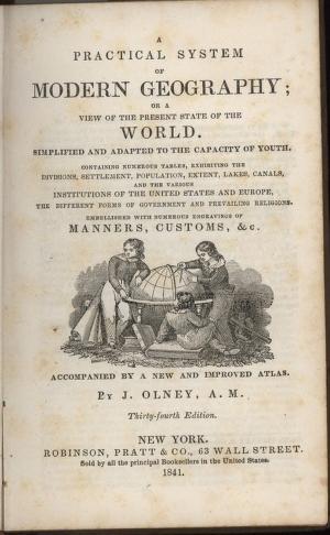
"A Practical System of Modern Geography"

Title page
(c) Pocumtuck Valley Memorial Association, Deerfield MA. All rights reserved.
Contact us for information about using this image.

As printing technologies improved in the 19th century, schoolbooks, such as this geography text, increasingly contained engraved illustrations to engage readers. Although these illustrations were often inaccurate or stereotypic they provided students with visual images of unfamiliar peoples such as African slaves in Southern States and Native Americans "out west". These books were a real "window to the world" for children in a time before TV, radio or movies and with access to few magazines or newspapers. Ideas and images absorbed from these books would color the thoughts and beliefs of the children who studied them.


top of page

Share this image with a friend.
Simply enter their e-mail address below and we'll send them this image in an e-mail greeting, along with a link to see the image on our site.

To E-Mail Address *
From E-Mail Address *
From Name
Message

* = Required


button for Side by Side Viewingbutton for Glossarybutton for Printing Helpbutton for How to Read Old Documents


Home | Online Collection | Things To Do | Turns Exhibit | Classroom | Chronologies | My Collection
About This Site | Site Index | Site Search | Feedback